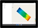
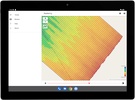
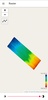

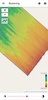

TopoTool: Topographic Mapper is an essential application if you're looking to survey land surfaces using your Android device. Designed for efficiency and accuracy, it allows you to capture data and transform it into digital raster models, which are indispensable for land analysis, simulation, or design projects. With the capability to export these models, you can easily integrate this data into software like QGIS for further processing.
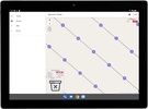
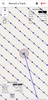
The app supports a variety of input methods, including internal GPS, Bluetooth, and USB-Serial GNSS (RTK) receivers, as well as CSV and GPX files, ensuring flexibility in how you gather your data. Outputs can be saved in multiple formats like GPX, Ascii Grid, or as image files along with a corresponding world file, making it easier to share and utilize your data in different environments.
The application streamlines the process of converting on-site geographical data into actionable digital formats, enhancing the precision of your land-surface projects. The software distinguishes itself as the go-to solution for topographic mapping directly via your Android device. Whether you are involved in professional land management or simple geographical surveys, this tool provides a robust platform for your topographic mapping needs.
Requirements (Latest version)
- Android 8.1 or higher required

Comments
There are no opinions about TopoTool: Topographic Mapper yet. Be the first! Comment